Tampilkan postingan dengan label citra satelit. Tampilkan semua postingan

Rabu, 15 April 2009

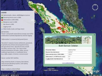
Deforestation maps for Sumatra on Google Earth

Despite many years of research in conservation biology, precise maps of tropical deforestation that document the global spatial extent of tropical forests destruction are generally not available outside of the scientific community, says David Gaveau a researcher from Durrell Institute of Conservation and Ecology. For nearly seven years, Gaveau has been documenting forest destruction on the island of Sumatra since early 1970s using satellite technology. He publishes his full-resolution maps and scientific results using Google Earth.


Image courtesy of David Gaveau
In a move to support the Indonesian government in its mission to inform the general public and decision makers about the true scale of environmental destruction on the island of Sumatra, Gaveau created the first world’s website (sumatranforest.org) that puts precise maps of tropical deforestation freely at user's fingertips. Through a link on the website, maps of tropical deforestation will unfold onto Google’s digital Earth in full resolution (up to 1:150,000 scale). Internet users will obtain a bird’s-eye view of Sumatran forest landscapes, and the threats they are facing inside and outside protected areas.

"Among the most inspiring and challenging duties we face in the conservation community, is to put the full range of tropical deforestation worldwide for everyone to see to improve ecological transparency, a key requirement of sound environmental governance," said Gaveau.

Gaveau is now working towards the development of a free online cartographic database of the Earth’s tropical forests, and hopes to find investors that are willing to fund this effort.

"Our duty is to put the full range of tropical deforestation worldwide for everyone to see."

Sumatra has lost roughly half of its forest cover since 1985, mostly due to logging and conversion for agriculture. Environmental group WWF says there has been an 84 percent decline in elephant populations and a 70 percent in the number of Sumatran tigers on the island since 1982.

source information : http://news.mongabay.com/2009/0330-google_earth_sumatra.html

Situ Gintung dari Google Earth...

Kronologi Jebolnya tanggul Situ Gintung yang dihimpun okezone,menurut keterangan warga Kampung Situ, Ibu Erna, Ibu Lina, dan Pak Mulyadi.

Kamis 26 Maret

Pukul 16.00 WIB, hujan deras disertai es dan angin kencang melanda kawasan Jakarta Selatan dan sekitarnya, termasuk wilayah Ciputat dan Cirendeu.
Pukul 23.00 WIB, warga mulai mendengar suara gemuruh dari arah tanggul.
Pukul 24.00 WIB, beberapa warga mulai berbenah dan siaga.

Jumat 27 Maret

Pukul 03.00 WIB, warga mulai mendengar suara gemuruh lebih keras dari sebelumya. Suara berasal dari arah tanggul. Tanggul jebol.
Pukul 03.30 WIB, air sudah menerjang Kampung Situ RT 1/8 Cirendeu, Ciputat, Tangerang, Banten.
Pukul 04.00 WIB, warga mulai mengungsi. Air meninggi.
Pukul 05.00 WIB, Beberapa warga mulai naik ke atap rumah, pertolongan dari warga yang rumahnya tidak terendam.
Pukul 08.00 WIB, empat warga dibawa ke RS Fatmawati.
Pukul 10.00 WIB, Kapolres Tangerang datang meninjau lokasi.

ebolnya tanggul Situ Gintung tampaknya turut menghanyutkan isi danau keluar. Ikan Patin seberat 45 kg yang diduga berasal dari danau ditemukan warga di sungai.


Berikut Peta Situ Gintung dilihat dari Google Earth :


View Larger Map

-- end --


source information : http://bumiwisata.blogspot.com/2009/03/situ-gintung-jebolnya-tanggul-wisata.html

Rabu, 03 Desember 2008

Penginderaan Jauh - Mixed Pixel Analysis

Penginderaan Jauh - Mixed Pixel Analysis

Penginderaan Jauh adalah ilmu dan seni dalam ekstraksi informasi mengenai suatu obyek, wilayah, atau fenomena melalui analisis data yang diperoleh tanpa melalui kontak langsung dengan obyek, wilayah, atau fenomena yang dikaji itu (Lillesand & Kiefer, 1990).

Menurut Ford, 1979, dalam Sutanto, 1992 mengatakan bahwa citra penginderaan jauh adalah gambaran visual tenaga yang direkam dengan menggunakan piranti penginderaan jauh.

Sebagai "gambar" maka citra mempunyai unsur yang terkecil dalam gambar yakni yang disebut sebagai piksel.
Piksel sendiri berasal dari akronim bahasa Inggris Picture Element yang disingkat menjadi Pixel.
Menurut Sutanto, 1992 beliau menuliskan bahwa Piksel adalah unsur data dengan aspek spasial dan spektral.

Seperti halnya kita yang mengenal Warga Asli atau Pribumi dan Warga Campuran...(*maaf bukan rasisme lho...)
Di dalam piksel juga dikenal yang namanya piksel murni (pure pixel) dan piksel campuran (mixed pixel).

Ini cuman sekedar menulis yang pernah ditulis oleh para penulis-penulis...
Pathik Thakkar dari Universitas Texas, Dallas dalam presentasinya mengenai "Mixed Pixel Analysis" mengulas secara ringkas ke dalam 44 slide presentasi.

Dimulai dengan overview bahwa resolusi spasial dari kebanyakan sistem sensor satelit yang merekam bumi lebih besar dari ukuran obyek di lapangan, biasanya satu piksel di citra satelit meng-koper lebih dari satu obyek atau kenampakan yang ada di permukaan bumi, piksel-piksel dalam citra yang meng-koper (mencakup/mewakili kenampakan dari) lebih dari satu klas obyek di lapangan/permukaan bumi merupakan mixed pixel atau piksel campuran.

Rabu, 05 November 2008

ENVI 4.5 - ENVI Modules (1)

What is ENVI?

ENVI is the premier software solution for processing and analyzing geospatial imagery used by GIS professionals, scientists, researchers, and image analysts around the world. ENVI software combines the latest spectral image processing and image analysis technology with an intuitive, user-friendly interface to help you get meaningful information from imagery.

ENVI Modules


ENVI Feature Extraction Module

Quickly and easily extract features from imagery with this object-based tool.

Today you need to find and identify features of interest within geospatial imagery. But, the process of manually locating and digitizing these features can be complex and time consuming, and spectral content is often limited, reducing the accuracy of standard classification methods.

The new ENVI Feature Extraction Module allows you to quickly, easily and accurately extract features from high resolution imagery. This add-on module to ENVI uses object-based image analysis technology so you can extract features from readily available pan and multi-spectral imagery and data.


Rabu, 22 Oktober 2008

News From ERDAS


ERDAS is great Business Company...
Since 13 Oct till 21 Oct News from ERDAS is very exciting to GIS and Remote Sensing Communities..

The Earth to Business Company
At ERDAS, we help organizations harness the information of the changing earth for greater advantage, by creating Geospatial Business Systems that transform our earth's data into business information. We are The Earth to Business Company.


21 October, 2008
ERDAS Releases Map2PDF for IMAGINE
Norcross, GA – ERDAS Inc. announces the release of Map2PDF for IMAGINE, a new product combining TerraGo Technologies’ Map2PDF (now called Publisher) with the power of ERDAS IMAGINE®, the industry’s leading and most complete collection of software tools designed to manipulate, process and understand imagery and vector data.
-----------------------------------------------------------------------------


16 October, 2008
ERDAS Announces Automated Feature Extraction Solution: IMAGINE Objective
Norcross, GA — ERDAS announces the release of IMAGINE Objective, a new tool providing object-based multi-scale image classification and feature extraction capabilities for building and maintaining accurate geospatial content.

Since the open Beta earlier this year, the IMAGINE Objective workflow has been streamlined, based on customer feedback and interaction. IMAGINE Objective includes a set of tools for feature extraction, update and change detection, enabling geospatial data layers to be created and maintained using remotely sensed imagery. With IMAGINE Objective, imagery and geospatial data of all kinds can be analyzed to produce GIS-ready maps.

-----------------------------------------------------------------------------------

15 October, 2008
ERDAS Announces a Free Webinar — Bigger, Stronger, Faster (ERDAS Image Web Server 2009)
Norcross, GA – ERDAS is offering Bigger, Stronger, Faster, a free webinar on Thursday, October 23, 2008, highlighting ERDAS Image Web Server 2009. ERDAS Image Web Server 2009 distributes large volumes of geospatial image data to thousands of concurrent users.

Now supporting additional file formats (including GeoTIFF, MrSID and IMG), as well as JPIP and WMS-C, ERDAS Image Web Server implements true interoperability, simplifying the process of delivering and consuming data. In addition, ERDAS Image Web Server also increases user flexibility with automatic client-side reprojection.
------------------------------------------------------------------------------------------

14 October, 2008
ERDAS APOLLO 2009 Selected by China’s National Environmental Protection Ministry
Norcross (Georgia, USA) – China’s National Environmental Protection Ministry is implementing ERDAS APOLLO 2009, a unified enterprise platform for managing and serving large volumes of geospatial data located and distributed across an organization.

ERDAS APOLLO Image Manager is being implemented to store and share the Ministry’s gridded data throughout the enterprise. Setting-up Open Geospatial Consortium and International Organization for Standardization (OGC/ISO) compliant web services, ERDAS APOLLO Server will catalog and deliver all the geospatial data of the Ministry’s enterprise over the web. Beijing Digital LandView Technology Company (Beijing LandView), ERDAS’ authorized distributor in China is providing ERDAS APOLLO, as well as ERDAS IMAGINE®, IMAGINE VirtualGIS®, IMAGINE Vector™, IMAGINE Easytrace™, IMAGINE Autosync™ and IMAGINE Deltacue™ and other IMAGINE add on modules to the National Environmental Protection Ministry.
------------------------------------------------------------------------------------------


13 October, 2008
Best of Both Worlds: ERDAS ER Mapper 7.2 Includes ERDAS IMAGINE® 9.3
Norcross, GA – ERDAS announces ERDAS ER Mapper 7.2, the next release of the solution for visualizing, enhancing and combining images. ERDAS ER Mapper provides advanced image processing and compression capabilities widely used in a variety of industries including oil, gas and mineral exploration.
--------------------------------------------------------------------------------------------
Additionally, ERDAS ER Mapper 7.2 offers 64-bit compression, allowing huge sets of imagery (over 5TB of data) to be mosaicked and compressed. This release also provides a new projection engine with over 3200 predefined coordinate systems, over 1100 datum shifts, 50+ mathematical projections, local and global vertical datums and industry-standard EPSG support for seamless data sharing (including better GeoTIFF and JPEG 2000 projection system handling). New file formats are also directly readable for data sharing, including MrSID, IMAGINE IMG, RPF (CIB and CADRG).
-------------------------------------------------------------------------------------------

source information : http://www.erdas.com/

Keep Study and Do The Best Get The Best !!!


Best Regards,

KPJ2001

Jumat, 10 Oktober 2008

GeoEye Releases First Image


Press Releases

GeoEye Releases First Image Collected by Its New GeoEye-1 Earth-Imaging Satellite
World's Highest-Resolution, Color Satellite Image of Kutztown University in Penn. Showcases GeoEye-1's Exceptional Quality

PRNewswire-FirstCall
DULLES, Va.
(NASDAQ:GEOY)

DULLES, Va., Oct. 8 /PRNewswire-FirstCall/ -- GeoEye, Inc. (NASDAQ: GEOY), a premier provider of satellite, aerial and geospatial information, released today the first, color half-meter ground resolution image taken from its GeoEye-1 satellite. The satellite has been undergoing calibration and check-out since it was launched on Sept. 6 from Vandenberg Air Force Base in Calif. The Company will begin selling GeoEye-1 imagery products later this fall.

..................................................... more complete information http://geoeye.mediaroom.com/index.php?s=43&item=308

-------------------------------------------------------------------------------------------------

Google's Super Satellite Captures First Image


This bird's-eye view of Kutztown University in Pennsylvania was the first image ever seen by the GeoEye-1, the world's highest-resolution commercial satellite sponsored by Google, when it opened its camera door earlier this week.

The 4,300-pound satellite collected the image at noon EDT on Oct. 7 while moving from the north pole to the south pole in a 423-mile-high orbit at 17,000 miles per hour, or 4.5 miles per second. The spacecraft can take photos at a resolution of up to 41 cm -- close enough to zoom in on the home plate of a baseball diamond, according to Mark Brender, GeoEye's vice president of communications and marketing.

........................................more complete information http://blog.wired.com/wiredscience/2008/10/geoeye-1-super.html

----------------------------------------------------------------------------------------
Citra satelit GeoEye mempunyai resolusi spasial 41cm, lebih tajam dari quickbird 61cm dan ikonos 1 meter. Coba bayangkan kalau kita terlantang di jalan dan kemudian terekam oleh satelit GeoEye, apabila tinggi badan kita sekitar 164 cm, maka kita akan menempati 4 piksel..hehe :)
------------------------------------------------------------------------------------------
--- Bumi semakin "tertelanjangi"---