Rabu, 15 April 2009

Deforestation maps for Sumatra on Google Earth

Despite many years of research in conservation biology, precise maps of tropical deforestation that document the global spatial extent of tropical forests destruction are generally not available outside of the scientific community, says David Gaveau a researcher from Durrell Institute of Conservation and Ecology. For nearly seven years, Gaveau has been documenting forest destruction on the island of Sumatra since early 1970s using satellite technology. He publishes his full-resolution maps and scientific results using Google Earth.


Image courtesy of David Gaveau
In a move to support the Indonesian government in its mission to inform the general public and decision makers about the true scale of environmental destruction on the island of Sumatra, Gaveau created the first world’s website (sumatranforest.org) that puts precise maps of tropical deforestation freely at user's fingertips. Through a link on the website, maps of tropical deforestation will unfold onto Google’s digital Earth in full resolution (up to 1:150,000 scale). Internet users will obtain a bird’s-eye view of Sumatran forest landscapes, and the threats they are facing inside and outside protected areas.

"Among the most inspiring and challenging duties we face in the conservation community, is to put the full range of tropical deforestation worldwide for everyone to see to improve ecological transparency, a key requirement of sound environmental governance," said Gaveau.

Gaveau is now working towards the development of a free online cartographic database of the Earth’s tropical forests, and hopes to find investors that are willing to fund this effort.

"Our duty is to put the full range of tropical deforestation worldwide for everyone to see."

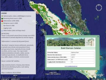
Sumatra has lost roughly half of its forest cover since 1985, mostly due to logging and conversion for agriculture. Environmental group WWF says there has been an 84 percent decline in elephant populations and a 70 percent in the number of Sumatran tigers on the island since 1982.

source information : http://news.mongabay.com/2009/0330-google_earth_sumatra.html

Situ Gintung dari Google Earth...

Kronologi Jebolnya tanggul Situ Gintung yang dihimpun okezone,menurut keterangan warga Kampung Situ, Ibu Erna, Ibu Lina, dan Pak Mulyadi.

Kamis 26 Maret

Pukul 16.00 WIB, hujan deras disertai es dan angin kencang melanda kawasan Jakarta Selatan dan sekitarnya, termasuk wilayah Ciputat dan Cirendeu.
Pukul 23.00 WIB, warga mulai mendengar suara gemuruh dari arah tanggul.
Pukul 24.00 WIB, beberapa warga mulai berbenah dan siaga.

Jumat 27 Maret

Pukul 03.00 WIB, warga mulai mendengar suara gemuruh lebih keras dari sebelumya. Suara berasal dari arah tanggul. Tanggul jebol.
Pukul 03.30 WIB, air sudah menerjang Kampung Situ RT 1/8 Cirendeu, Ciputat, Tangerang, Banten.
Pukul 04.00 WIB, warga mulai mengungsi. Air meninggi.
Pukul 05.00 WIB, Beberapa warga mulai naik ke atap rumah, pertolongan dari warga yang rumahnya tidak terendam.
Pukul 08.00 WIB, empat warga dibawa ke RS Fatmawati.
Pukul 10.00 WIB, Kapolres Tangerang datang meninjau lokasi.

ebolnya tanggul Situ Gintung tampaknya turut menghanyutkan isi danau keluar. Ikan Patin seberat 45 kg yang diduga berasal dari danau ditemukan warga di sungai.


Berikut Peta Situ Gintung dilihat dari Google Earth :


View Larger Map

-- end --


source information : http://bumiwisata.blogspot.com/2009/03/situ-gintung-jebolnya-tanggul-wisata.html

ERDAS Software 2009, Version 9.3.2

ERDAS Insights

Announcing ERDAS Software 2009, Version 9.3.2
By Mladen Stojic, Senior Vice President, Product Management & Marketing, ERDAS

Earlier this month, ERDAS announced the release of ERDAS Software 2009, Version 9.3.2, featuring the complete portfolio of Geospatial Business Systems for authoring, managing, connecting and delivering information. This includes new releases of ERDAS IMAGINE®, LPS, ERDAS ER Mapper, ERDAS Extensions for ArcGIS, ERDAS APOLLO and ERDAS Image Web Server.

This release includes numerous customer-driven enhancements across the product lines. These solutions facilitate businesses in capitalizing on the geospatial information value chain used to build applications for understanding our changing Earth.

ERDAS Software 2009, Version 9.3.2 is part of ERDAS’ annual release schedule, which includes a major release of products each Fall, as well as a minor release in the Spring. Some of these products offer free or trial downloads. ERDAS TITAN will be released later in April. Software maintenance customers may download the new versions of their desktop products from www.erdas.com/support and enterprise products on www.erdas.com (on the product’s webpage).

A complete document outlining What’s New in ERDAS Software 2009, Version 9.3.2 is available on the company homepage. In addition, product specific what’s new documents are available on the product pages.

source information : ERDAS Earth to Business E-Newsletter : April 2009